Tuesday, October 19, 2010

Vandan Fort

Fort: Vandan
Height: 3400 feet above MSL

Base Village: Belmachi , Ibrahimpur

Difficulty : Medium


After completing Chandan I went to Vandan fort. The route to Vandan from Chandan is via the col between Chandan and Vandan. One has to traverse Chandan fort keeping the fort to your right and get to the col between Chandan and Vandan and then once at the col we can see a rock face in front of us. The route to the top would be taking a right from the rock face and getting on top of the face and then a route towards the left keeping the fort to your right.

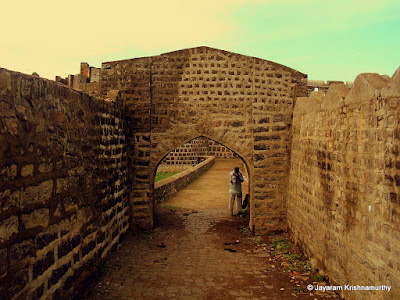
On going ahead one can see the main door of Vandan fort but the approach to the door is no longer present as its destroyed and we climb from the right of the main door. The way is through rocks and bushes so be careful.


Once on top of the fort you get to the lower level of the fort where there is nothing and one has to climb steps to go to the main upper level of the fort. On top there is nothing to see except a dargah and a tomb of some saint. Also a granary on top. Other than that Vandan is covered in tall bushes as not many people go there. There is also a hill in the middle of the fort with nothing on top. Most of the buildings there were destroyed during British rule.
There are a lot of huge water tanks on top but not one of them is potable except one or two of them.

After completing Vandan fort I traversed back the whole route upto Ibrahimpur as I had kept my bike there. This trek was done after a long time and was very good.

History: Vandan fort was constructed as the same time during Chandan fort and there's no specific history about that fort.

Chandan Fort

Fort: Chandan
Height : 3400 feet above MSL
Difficulty: Medium
Base village: Belmachi, Ibrahimpur
Route : Pune-Katraj-Shirval-Surur-Bhuinj-Rautwadi-Ibrahimpur (90 kms approx)

Had gone to the forts of Chandan and Vandan on 16th October 2010. Initially it was planned with Rahul but due to some problem he dropped out and I went alone. Started at 6am and reached Ibrahimpur around 7.30am. Asked for the route to the fort and started along. The fort of Chandan has a dargah on top hence steps have been constructed at intervals for pilgrims to climb to the top however they are crude.


It takes about 30-40 mins to get to the top of the fort.
The main door of the fort is no longer present however one part of it is still present. As soon as you enter the top you can see a shiv temple on the left side. This shiv temple is peculiar with multiple shiv lings on a single stone. A local had also come to the temple and was performing pooja there.

Going ahead there is a big dargah on top. Every year lot of pilgrims throng there during auspicious days (as per the locals). On top there are ruins of a wada with only the foundation remaining and one more ruined ammunition or granary room.
There is also a well on top but the water is not potable. The fort is spread over a vast area but no other remains are present. On the other side one can see the looming Vandan fort but the way to the fort Vandan is not from there but one has to come back from the path where one started and traverse Chandan and get to Vandan fort. It takes about 40 mins to roam on top of the fort and come back.

To get to Vandan fort one has to retrace their steps back towards Ibrahimpur and at a certain point (where there is a shed constructed one has to take a right from there and traverse Chandan fort , one more temple is in the way) and get to the col between Chandan and Vandan fort to get to top of Vandan fort.

History of the fort: According to the evidences of copper-inscriptions(Tamralekh) of 1191-1192 B.C., these forts were built-up by king Bhoj II of Shilahar dynasty. Shivaji Maharaj overpowered Chandan-Vandan along with Kalyangad, Sajjangad, Ajinkyatara during the campaign of Satara in 1673. Later, during the regime of Sambhaji, Amanullah Khan attacked the troop of Maratha soldiers on Chandan-Vandan. 25 horses, 20 guns, 2 ensigns, 1 kettle-drum were lost in the hands of Mughals in this battle. Marathas ruled this region up to 1689 B.C. Afterwards Mughals ruled this fort. In 1707, Chhatrapati Shahu Maharaj won this region during rainy season. In 1752, Dadopant was accompanied by soldiers by Balaji Vishwanath to keep close watch on Tarabai. Later, British ruled over these forts.

Tuesday, August 10, 2010

Ausa Fort

Fort : Ausa
Location : Ausa , Latur district
Type: Land fort

Route(s) :

1. Latur - Ausa (20 kms)

2. Pune - Tembhurni - Kurduwadi - Barshi - Osmanabad - Tuljapur - Ausa (365 kms)
3. Pune - Latur - Ausa (344 kms)
4. Pune - Solapur - Ausa (353 kms)

After Udgir we started for Ausa fort , the last fort of the trek. Ausa is located about 20 kms from Latur on the Latur-Solapur highway.
We reached the fort in about 2 hours from Udgir with a lunch break in between.

This fort is also under the control of the ASI and is open from 9am to 5pm. Photos are not allowed , but you can prove to them that this wont make it to some press news , usually the guards allow to take photos.

The fort has some outer walls and entrances. The fort is basically built in a depression (khandak). There are a lot of structures on the fort and cannons on the fort. The inner part of the fort is converted into a garden. There is a huge well in between the fort and has a lot of water and water channels underneath. We could even heard the sound of peacocks inside the shrubs in the fort but couldn't see any of them. The walls and bastions of the fort are crumbling due to tree growth but the ASI is trying to restore them. Most of the structures are crumbling and may fall down soon. There are lot of cannon balls too kept inside one of the entrances.


There is no specific recorded history of the fort.

The main entrance door of Ausa fort


Seal of British Empire on a cannon


A deep well inside the fort , water channels below


Expanse of the Ausa fort


One of the entrances of the Ausa fort


One of the cannons in Ausa fort


Firing line of cannons just ahead of an entrance door


Crumbling bastions and walls of the Ausa Fort


Lots of cannon balls in the fort

Udgir Fort

Fort: Udgir
Location : Udgir city , Latur District
Type : Land fort
Route (s) :

1. Nanded - Loha - Ahmadpur - Udgir (110 kms)
2. Pune - Latur - Udgir (387 kms)
3. Latur - Udgir (65 kms)

After Kandhar fort we proceeded to Udgir fort. We reached Udgir at about 11am and went inside the fort.

The fort is well maintained and is under ASI control. It is open from 9am to 5pm only for visitors and apparently photos are not allowed to be taken but if you have a small cam you can sneak it in like I did :)

There are lot of entrance doors in the fort with various carvings. Lots of dilapidated halls and structures and mahals in the fort. There are big cannons in the fort and are intact. Most of the walls and bastions are intact in the fort.

This fort also has a network of underground tunnels and caves most of which is hidden now. Udgir fort also houses the temple/ashram of Udaygir Baba. This location is serene with a water tank and is worth seeing.

History of Udgir and the fort : (Source: www.udgir.com)

Udgir has a great historical significance. It has witnessed the war between the Marathas and the Nizam of Hyderabad which took place in 1761. The Marathas led by Sadashivrao Bhau defeated the Nizam and the treaty of Udgir was signed.

The fort of Udgir stands in all its glory speaking volumes about the Indian history and Indian culture. The fort is bounded by a 40 feet deep trench as the fort is built at the ground level. In the fort are several palaces Durbar halls and most importantly the Samadhi of Udaygir Maharaj which is 60 feet under the normal ground level. This is a place of great reverence to the people of the region. The fort has some rare inscriptions written in Arabic and Persian.

Main entrance to Udgir Fort

Dilapidated structures inside the Udgir Fort


Through one of the entrance doors in the fort


The fort expanse


Udaygir Maharaj temple and pond inside the fort


Some hall inside the fort , typical Nizam/Mughal type architecture


Cannon on top of the fort


One more hall


Palaces inside the fort

Monday, August 09, 2010

Kandhar Fort

Fort: Kandhar
Type: Land fort
District : Nanded
Route: Nanded - Loha - Kandhar (42 kms)

After visiting Nanded fort we started for Kandhar fort located about 42 odd kms from Nanded. We stopped in between at Loha to have "Dahi che Dhapate" which is similar to "Thali Peeth" or Paratha. After a filling breakfast we continued onwards to Kandhar fort.

We came to Kandhar and went to the fort only to know that the fort is closed by ASI and does not open until 10am on Sundays. It was 8.50am and we didnt want to waste time as we had to cover 2 more forts and continue ahead to Pune so we just went upto the entrance door, took some photos. Went round the fort outside and returned back.

There is no recorded history of Kandhar fort but it was ruled by the Nizam of Hyderabad during his rule.

Kandhar fort from outside


Approaching the entrance


Bastions and walls intact, thanks to ASI for maintaining them


The main entrance door of the fort


Masjid or tomb built on a platform on the moat of the fort

Nanded Fort

Fort : Nanded fort
Location : Nanded city
Type : Land fort

District : Nanded
Route : Nanded City - Arab Galli.


After visiting Mahur we halted for the day in Nanded city. Nanded city is famous for Gurudwara , Guru Gobind Singh a guru of the Sikhs supposedly attained martyrdom in Nanded hence a Gurudwara was built here. Nanded fort is located on the banks of the Godawari river and is located in the old city. The place is known as Arab Galli and is quite filthy with very small roads to go in. The fort is now part of the water pumping station at Nanded and most of it is dilapidated. Inside the fort there are some broken structures , a bastion and a beautiful lake and some cannons.

There is no notable history of the fort or its rulers , however there are references to this fort goes back to 7th Century BC when it was ruled by the Magadh Kingdom. Na
nded was under the rule of Nizam of Hyderabad too and was amalgamated into Maharashtra after the Nizams rule ended


Mahur fort

Fort: Mahur
Location : Mahur , Nanded district.
Type: Hill fort
Route (s) :
Jintur - Aundha Nagnath - Hingoli - Pusad - Mahur
(80 kms)
Pune - Latur - Nanded - Mahur (450 kms)


After Jintur fort , we started for Mahur fort. This fort is located in Nanded district and is a hill fort. This fort is located directly opposite the hill where the Renuka Mata temple is located in Mahur. We need to climb about 20 mins to get to the top of the fort. Most of the bastions and walls are intact and the views are good. On top there are no notable structures except the main door , walls and bastion and a Kali temple which is famous and people visit. Apart from that the top of the fort is covered in thick vegetation and its difficult to go around there. There is a water tank supposedly on top but as the weather was so cloudy we could not find it. The views from the top are good and we experienced cloudy weather making the atmosphere more cool.


History ( from : http://www.maharashtratourism
.gov.in/MTDC/HTML/MaharashtraTourism/TouristDelight/Forts/Forts.aspx?strpage=MahurFort.html) Being situated on the main route from the north to the Deccan, Mahur has a long history. There is evidence to show that Mahur, ancient Matapur, was an important place at the time of the Satavahanas and the Rashtrakutas. The Renuka temple on an adjoining hill was built by the Yadavas. After remaining with the Gond rulers for sometime, Mahur passed on to the Bahamanis in the 15th century and was made a Suba. In the 16th century, Mahur, being strategically placed at their centre, faced a lot of fire from the infighting between the Nizamshahi, Adilshahi and Imadshahi rulers. Then in the early 17th century, Mahur became a part of the Mughal Empire and came to be ruled by their Subedars. When Shahjahan rebelled against his father Jahangir, he took refuge in the Mahur fort along with his wife and children, including 6 years old Aurangzeb.


Hill of Mahur fort , shrouded in clouds


One of the bastions of the fort


Kali mata temple on top of Mahur fort


Flagstaff (picturesque view)


Donation collection pot near the temple in the fort


Entrance door from inside


Jintur (Nemgiri) Fort

Fort : Jintur also known as Nemgiri
Town : Jintur

District : Parbhani
Type : Hill Fort
Route: Pathri - Valur - Lalthane - Jintur (60 kms)

The next fort was Jintur , we took the route through small villages and at one place the tavera was stuck in mud and water. We had to push it o
ut and then continued to Jintur. Jintur is a small town famous for its Jain caves. The fort of Jintur is also known as Nemgiri is built on a hill known as Nemgiri and infact it protect the Jain caves. Its also a Jain shrine. To get to the fort we need to go via the town center about 1km ahead. We can see the hill of Nemgiri quite clearly and there is a narrow road going all upto the top. The fort is not very huge but the caves are worth seeing. The carvings and sculptures are worth looking at. No photos allowed inside as its a Jain temple.

There is no specific history as to who built the fort but Rashtrakuta kings have ruled in Jintur. Some brief history of the caves (Source : http://www.
jainteerth.com/teerth/jintur.asp) In ancient times this area was famous as Jainpur, this was developed in the time of Emperor, Amogh Varsha of Rashtrakut Family. Later in the middle period of Indian History, this was destroyed by invaders, and its name was changed to Jintur, the current name. At that time 300 Jain families & 14 Jain Temples were here. Today two temples out of them only are present. Later in the year 1609 A.D. this Kshetra was reconstructed and developed by Shri Veer Sangavi of Bagherwal Cast. It is said that Samavsharan of Lord Mahaveer came here and the Last Shrut Kevali Acharya Bhadrabahu with his 12000 scholars including Chandragupt Maurya (The great emperor of ancient India) and the famous idol of Lord Parsvanath was also installed by them, this idol is staying in the space 3 inches high from surface without any support, so this is called Antariksha Parsvanath. According to archaeologists idols of this Kshetra are old about 1000 years or more.

Atishaya – At Nemgiri Hill, in Cave No. 5 miraculous idol of Lord Antariksha Parsvanath is very wonderful staying in the space 3 inches high from surface. It is said that desires of pilgrims are materialized after prayers & worships here. King Cobra often comes here and gods of heaven also come here for worships.


Pathri Fort

Fort: Pathri
Type : Land fort

Base Village : Pathri
District : Par
bhani
Route: Ahmednagar - Pathardi - Beed - Majalgaon road - Pathri


Pathri is a small village in the Parbhani district known for its historical importance. Though there is nothing significant there but it was an important par
t of erstwhile Berar region during the rule of Akbar and later the Mughals. The fort of Pathri is a crumbling non-descript type of fort with almost all the walls and bastions gone and only one entrance remaining intact. There is a masjid in the fort and there is a massive stepwell in the fort which is of interest. History Pathri was supposed to be built in 1524 or some year nearby by Allaudin Imad Shah. Burhan Nizam Shah of the Ahmednagar Kingdom attacked this fort in 1526 and captured it. No other significant history of the fort exists anywhere.


Palshi Fort

Its time to trek again after a long time and after the Vidharbh Trek in March. An avid trekker friend told me that he was going to cover the forts in the districts of Parbhani , Nanded and Latur as a pilot trek/trip. Basically all of them are land forts but what the heck. We started on Friday, 6th August at 2.30pm from Pune in a hired Tavera. It was decided that we cover one more fort named Palshi located in the Ahmednagar district and on the route.

Fort: Palshi
Type : Land Fort
District : Ahmednagar
Route : Pune - Shirur - Ralegan Siddhi - Parner - Kanhur Pathar - Takli Dhokeshwar - Palshi (150 kms approx)

This fort houses a village inside it and almost all of its bastions are intact. There is an amazing shiv temple inside the fort but there are no other structures inside worth viewing. There is no known history of the fort except that this fort was a transit point of keeping Sambhaji Maharaj when he was captured by the Mughals and taken prisoner.

Entrance door to Palshi fort


Inscription on one of the doors of Palshi fort


Bastions and wall of the fort

Tuesday, March 02, 2010

Sindkhed Raja (Wada and Fort)

Base: Sindkhed Raja (Buldhana district)
Route: Rohinkhed - Buldhana - Chikhli - Deulgaon Raja - Sindkhed Raja (100 kms).

Places to see: Wada of Raja Lakhuji Jadhav (Jijabai's father) , Kala Killa , Samadhi of Lakhuji Jadhav and Someshwar Temple


Sindkhed Raja is famous for the birth place of Jijabai (Shivaji Maharaj's mother). This was the place where Raja Lakhuji Jadhav (Jijabai's father) ruled and lived. The place has a lot of places to see.


1. The Jadhav Wada This wada is located inside the city of Sindkhed Raja and is the birthplace of Shivaji Maharaj's mother Jijabai. One has to pay 2Rs to get a ticket to visit the Wada (a govt initiative). The wada contains big bastions and a beautiful entrance door. Inside there are many artifacts , statues, carvings. Also there are underground rooms in the wada where people used to stay.

Entrance to the wada of Raja Lakhuji Jadhav


Old artifacts and cannon kept inside the wada

The underground rooms in the wada, these were built to keep away the heat in the region. The underground rooms are very cool and keep away most of the heat in all seasons


The birthplace of Jijabai (Shivaji Maharaj's mother) in the wada

The darbaari hall inside the wada where proceedings used to take place
2. The Kala Kot or the Kala Killa (Black Fort)

This fort was built by the Jadhav's but not constructed fully. Only the bastions and outer walls are present , nothing inside.

The walls and bastions of the Kala kot


3. Samadhi of Raja Lakhuji Jadhav

Raja Lakhuji Jadhav was killed by treason by the Nizam at Devgiri fort in Aurangabad with 2 of his sons. There is a samadhi built in his memory in Sindkhed Raja. The samadhi is a nice structure of old times.

4. Someshwar Temple

This is an old temple supposed to have been built by Raja Lakhuji Jadhav on his mother's wishes. This is a Shiv temple with a Shiv Linga for worship.


The shiv linga inside the Someshwar Temple at Sindkhed Raja


This was the last place in our trek. The trek finally ended here after which we took a bus back to Pune.